
In the past 20 years London’s population has risen by two million, in 2015 hitting 8m – the most people who have lived in the capital since 1939. In just one day in October 2015 the London underground carried 4.735m passengers; every day the bus network deals with 6.25m passengers.
When Boris Johnson described housing all these people as “an epic challenge” in his 2014 Strategic Housing Assessment, he was not over-stating the case. We need to double house-building and build 42,000 new homes a year, every year, for the next 20 years. If anything the Mayor under-stated the scale of this challenge.
We’ve not seen building on that scale in London since a brief burst in 1930s, when of course we could build across miles of virgin countryside. What is more, it is not only housing that is needed. People need places to work and play too, and the latest prediction is for an 18% rise in London jobs over 20 years from 4.9m to 5.8m in 2036.
With 5,491 people per sq km, the capital is growing upwards. First solitary Centre Point and the NatWest Tower arrived, then the Canary Wharf cluster, and most recently the Gherkin, Shard, Walkie Talkie and Cheesegrater all surged up into the London skyline. A further ten tall towers accommodating 50,000 additional jobs are already planned for the City of London, transforming not only its skyline, but the experience of living and working in that area.
This population growth and the resulting effect on property is placing the planning system under unprecedented strain. New buildings are needed, but debate rages over where they should be, how big they should be, what they should look like, and so on. Making the right decisions has never been easy, but now it is harder than ever before and with the Mayor’s Office predicting a population of 11m by 2050 they are set to get harder still.
Four planning scenarios
Steven Butterworth, Senior Director at leading independent planning, economics and urban design consultancy, Nathaniel Lichfield & Partners, believes that when it comes to working out how to accommodate the future of London we need to decide between four broad scenarios: increased space cramming, increased densification, expanding London or decanting London.
He does not believe that space cramming is a viable option. “It might satisfy the numbers game but it also affects the quality of new homes environment and so is generally unpopular,” he says. “As such The Mayor and London boroughs are upholding the minimum space standards for new residential development in the London Plan.”
We are already seeing considerable densification in strategic growth locations aided by significant transport improvements. Butterworth points to the Greenwich Peninsula – where his firm NLP has just secured permission for Knight Dragon’s new masterplan – as well as Isle of Dogs, Stratford, and Vauxhall/Nine Elms.
Whether it is in these inner city locations, or into the suburbs and Home Counties, those tasked with planning face significant challenges. “We need to gain a clear understanding of how a place works, and its needs, so we can successfully masterplan change for its future and engage with the community and other stakeholders to share aspirations and creativity,” adds Butterworth. “If we are to create higher quality places within London at higher densities where people want to live and work, it is essential we get these elements right.”
It is a view shared by Simon Babes, MD at transport consultancy Movement Strategies. He says: “Demand is ahead of supply across London’s transport network. The real focus is how to extract more from the existing assets and manage demand until significant capacity enhancements such as Crossrail are delivered. We need to understand where people are travelling from and to, and why. He continues: “New technologies are presenting us with vast swathes of data that are potentially immensely useful – and are already being used in many ways, for example cellular data from mobile phone network operators, Oyster card data and footfall cameras in and around tube stations. However, data alone is not enough. We need to find a way to visualise that data if we are to understand and use it to its full effect.”
Visualising in 3D
Indeed, our experience working with architects, planners, engineers and developers has taught us that visualising data about an area in 3D can play a vital role in tackling these major development and infrastructure issues and futureproofing our cities.
Take for example, the London Land Commission, created in 2015, with a goal to identify brownfield land for development in public ownership and to help co-ordinate and accelerate the pace of land released for much needed homes in London. What if you could plot all of that information on a fully interactive model of our City, then overlay demographic, amenities and transport data? Will that then tell us where new schools, hospitals and houses would be best built to serve the growing population?
Using our own pioneering digital tools we’ve been able to work with developers and transport organisations to provide a clearer way to understand and use different types of complex data in our built environment, including traffic, pedestrians, proposed buildings and sunlight paths.
Bringing real data into visualisation only serves to advance our understanding. For instance at Bond Street underground station we used data from Legion, a piece of software for pedestrian movement simulation, to look at capacity issues at the station. Taking two Legion data-based scenarios, these were applied to a fully rendered 3D model of the station and made it possible to compare the journey times of a passenger arriving on a train into the station in 2011 versus 2016.
The 3D data was hugely compelling and enabled non-technical stakeholders to clearly see the strain the station would be put under with the increase in train frequency and passenger numbers. The 3D interactivity offered the ability to look at views you could never see in real life – top down, through escalators, macro station and micro tunnel views. And it must have been compelling enough, as the new exit is currently being built.
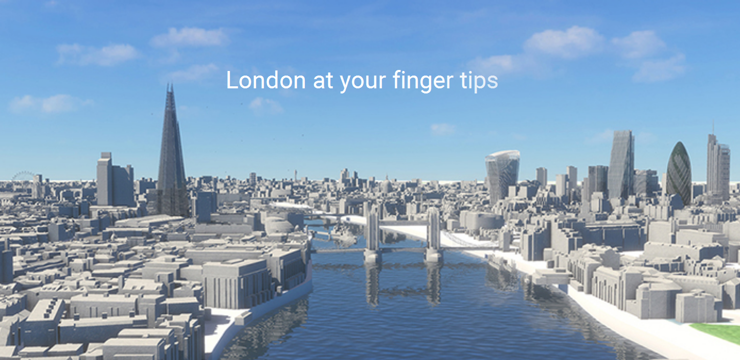
Visualising London
A couple of years ago, we recognised the need to digitally visualise all of central London in this way. The work culminated with the launch of VUCITY in 2015. A joint venture with Vertex Modelling, it is the first ever fully interactive 3D digital model of London. It covers more than 100 square kilometres of Central London, from Earls Court to ExCeL up to Euston and down to Nine Elms.
VUCITY brings together the ability to explore the whole city, whilst overlaying data interactively. It not only accurately shows the current built environment, but also allows us to toggle between existing and consented developments, offering a macro and yet detailed understanding of the development pipeline in London and helping to establish how the future city might look. In terms of planning new buildings, using our city model we can overlay sightlines, the London View Management Framework, transport links and sunlight paths to help the council planners understand proposals in context, as well as embedding live data feeds such as traffic cameras, to connect with our city in real time as we have never before.
In a city that needs to grow, visualising the data that’s available to us is the only way to help futureproof the planning of London and inform the debate that will always surround the development of this iconic city.
Wagstaffs will be exhibiting in the Innovation Forum at MIPIM 2016 in Cannes. Don’t miss their presentation! Didn’t register for MIPIM 2016 yet? Click here to attend!